The growth of Oxford's suburbs

'The old order changeth, yeilding place to the new': dons (old and new) on the High Street, 1882. Image © Oxfordshire County Council, Oxfordshire History Centre, ref: HT134.
Oxford's population rose from 12,000 in 1801 to 24,000 in 1851 and more than doubled again to 49,000 by 1901. In the mid to late 19th century the university had undergone a series of reforms which led to a large increase in the number of students, and hence in the number of academic staff (and their families). This in turn produced an expansion in demand for goods and services which provided more employment for working people, and as a result there was further growth in Oxford's population and an increase in the need for housing.
In 1868 undergraduates were permitted to live out of college for the first time, and many home-owners supplemented their income by letting out rooms to students: within two years there were 400 licensed lodging-houses in Oxford. In 1877 college fellows were allowed to marry and although a lot of them moved to the newly-developing middle-class suburb of North Oxford, the presence of their wives and families stimulated demand for goods and services throughout the city.
At the same time, there was an increasing divergence between people's homes and their workplaces, and Oxford's central parishes became less residential and more commercial. Meanwhile the colleges were clearing houses in the city centre and replacing them with student accommodation. Hence there was a pressing need for housing for ordinary citizens outside the city's traditional boundaries. Oxford's suburban expansion to the east, west and south gathered pace in the 1890s when there was a nationwide building boom, fuelled by rising real wages. The city's essentially medieval character was altered forever, and the poet Gerard Manley Hopkins spoke for many when he wrote disparagingly of the development of Oxford's 'base and brickish skirt'.
Expansion to the south: New Hinksey
In 1844 the Great Western Railway built the first railway line to Oxford, linking the city to the main London to Bristol line at Didcot. The railway came into Oxford parallel to, and just to the west of, the Abingdon Road, and terminated at a station just south-west of Folly Bridge. This map, drawn up prior to the building of the railway, shows the owners of the land over which it was to run as it approached Oxford.
The railway brought with it a demand for cheap local housing for railway employees. A man called Henry Greenaway, who lived in Newbury but who owned two large fields west of the Abingdon Road and half a mile south of Folly Bridge, was probably encouraged by this demand to sell his land for house-building. He divided the two fields into lots and sold them in 1847 and 1849. Each field was laid out with a single main street running down its centre from the Abingdon Road towards the railway. These streets, Lake Street and Post Office Street (now Vicarage Road), were linked by Cross Street (now Gordon Street).
![[New Hinksey OS 1878]](/images/photos/Local_history_section/Suburban_development/New_Hinksey_OS_1878.jpg "New Hinksey OS 1878")
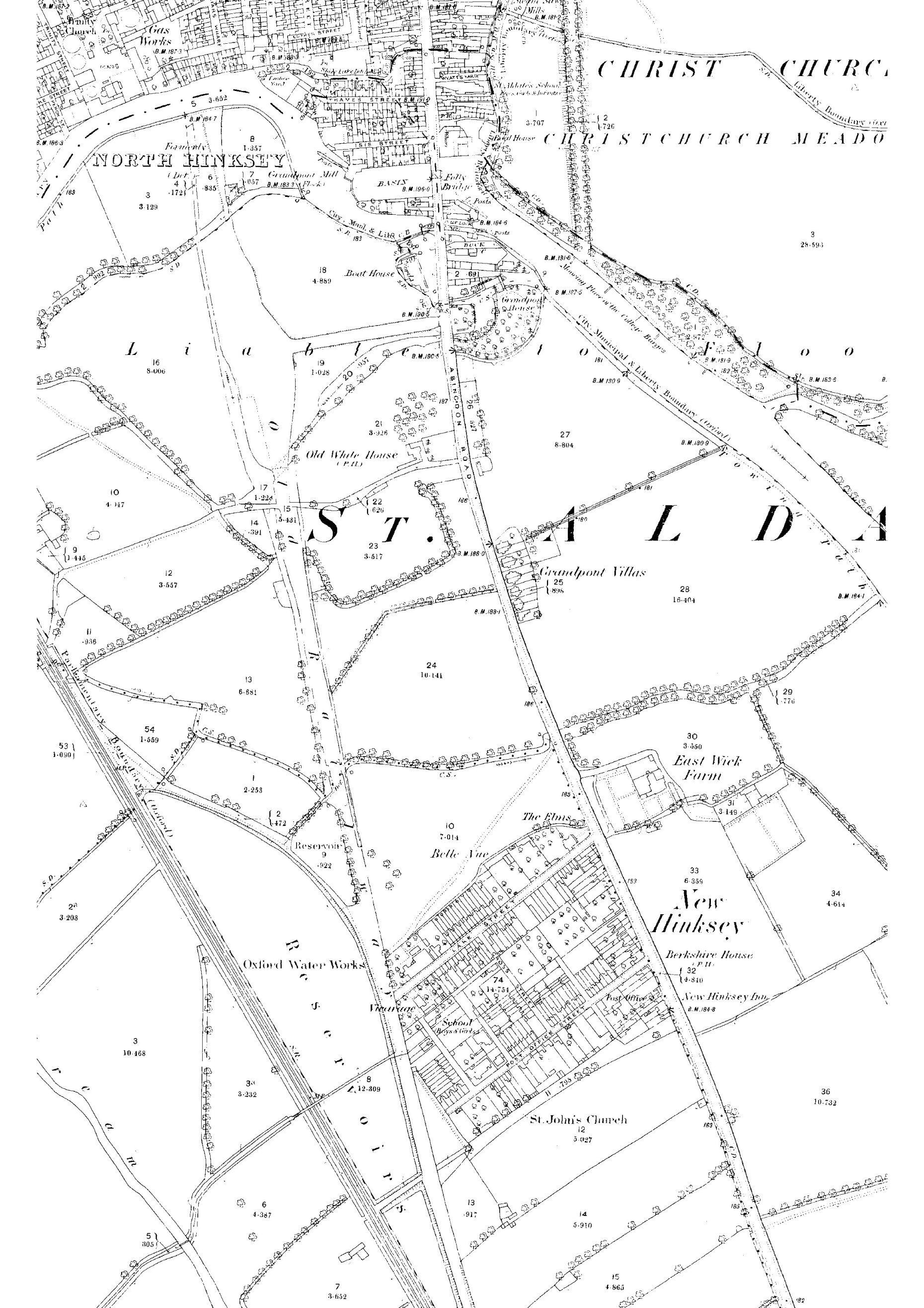
New Hinksey on the Ordnance Survey map of 1878, an 'island' suburb surrounded by open fields. Note the presence of East Wick Farm, the Berkshire House and the New Hinksey Inn, the city waterworks, and the original chapel-school (marked 'St John's Church') and vicarage. Gordon Street was at this time called Cross Street and Vicarage Road was Post Office Street. Vicarage Lane, School Place, Stewart Street and Green Place existed but had not yet been named; Summerfield was yet to be laid out. The original boundary between Greenaway's two fields, running parallel to, and between, Lake Street and Post Office Street, is discernible in property boundaries.

A ceramic plaque, above a bricked-in doorway on the side wall of 202 Abingdon Road (on the corner of Vicarage Road), which says 'RP June 29 1849'. According to the census, a man called Robert Palmer lived on this stretch of the the Abingdon Road with his family from at least 1851 until 1871; he was a brick maker. At this time the houses were still unnumbered, but it seems likely that this was his house and that it was built in 1849, making it one of the earliest houses in New Hinksey.
The new suburb was named New Hinksey after the nearby villages of North and South Hinksey; 'Hinksey' is made up of the Old English elements 'hengest' meaning 'horse' and 'eg' ['ey' in modern spellings] meaning island or area of slightly higher ground above flood level. Small terraced cottages were quickly built and by 1851 New Hinksey housed a total of 144 people. The majority of the dwellings were built up to the pavement edge, with no front gardens, as was characteristic of early and mid 19th-century development in other suburbs like Jericho and St Ebbe's. This map, drawn to accompany Henry Acland's Memoir on the cholera at Oxford, shows how many houses had been built in New Hinksey by 1854.
The growth of New Hinksey slowed after only a few years because of the gradual movement of railway activity from South to West Oxford. The London and North Western Railway (LNWR) opened its station at the eastern end of the Botley Road in 1851 (where the Saïd Business School is now) and a year later the Great Western Railway (GWR) opened its new station immediately adjacent (where the current railway station is). Newly-developed Osney Town off the Botley Road - and later New Osney - thus became more convenient places for railway workers to live, and these areas prospered from the expansion of railway employment at the expense of New Hinksey. Moreover, building plots were becoming available in other outlying parts of the city - notably in East Oxford - and potential residents and hence speculative builders were probably put off New Hinksey by the regular flooding and primitive sanitary arrangements.
But in 1856 the city waterworks were established at the end of Lake Street (now the South Oxford Community Centre), with grounds (now Hinksey Park) extending north as far as Eastwyke ditch. Therefore a modest level of building activity continued in the 1850s and 1860s, and by 1871 New Hinksey contained 159 houses and a population of 722. Conditions improved when main drainage was extended to the suburb in 1875, though flooding was still a regular problem, as in other low-lying areas of the city. In 1875 some of the affected families in New Hinksey were said to be 'in a wretched condition, being confined to their upper rooms, with no firing, very little clothing and many with scarcely any food to eat. The stench, too, in their houses arising from the flood is in some cases very offensive.' Despite this, Alfred Boffin, an Oxford baker whose famous Boffin's Tea Room was at Carfax, developed a large area of new housing in Lake Street in the early 1880s. Here he built six- and seven-roomed artisan houses of which ten fronted the existing street and the rest a new cul-de-sac which he called Summerfield.
- Read more about historic flooding in Oxford on Stephanie Jenkins's Oxford History website.
On the eastern side of Abingdon Road, where most of the land was owned by University College and Brasenose College, regular flooding prevented development and there were few buildings other than those of Eastwyke Farm and the nearby toll house. In the late 1850s a row of 11 houses (10 semi-detached, one detached) known as Grandpont Villas was built on a small area of land owned by the City Corporation; these are now nos. 65 to 85 Abingdon Road. (In the medieval period this had been the site of a Hermitage or Bridgewrights' house, occupied by the bridge hermits who were responsible for the repair of the Grandpont causeway and South (Folly) Bridge. Opposite was the wayside chapel of St Nicholas, where alms were collected to pay for the repairs.)
The beginnings of the Grandpont Estate
Following the complete closure of the Great Western Railway's Grandpont station in 1872 the area between Folly Bridge and the waterworks grounds was cleared and the station buildings and track dismantled and sold off as building materials. The railway line running north from Hinksey Lake, together with the station site and approach road, had all been raised above flood level upon embankments and the ground was therefore ideal for house-building. Moreover, the proximity of Grandpont to the city centre made it a potentially convenient place of residence for 'labourers, college servants and a few very small tradespeople and shopkeepers.' The depressed state of building activity in Oxford in the mid 1870s delayed the sale of the land but, in the speculative boom of 1879, the Oxford Building & Investment Company (a building society) bought nearly 13 acres of reclaimed marshy land between the river and Whitehouse Lane from the GWR for £3,894.
The company laid out the Grandpont Estate and divided it into 231 plots. Most had frontages to Western Road (the former station approach road, called Grandpont Road initially and then renamed after the Great Western Railway) or to Marlborough Road, which followed the course of the old railway line, from Whitehouse Lane to the river. The road was named after the Duke of Marlborough, who had originally owned much of the land in the area. Other plots were formed on the riverside meadows near Folly Bridge with frontages to roads named Brook Street and Buckingham Street (after former landowners) and Cobden Crescent (after Richard Cobden (1804-1865), the British Liberal politician whose defence of free trade was greatly admired by the Oxford Building & Investment Company). Cobden Crescent is curved because it follows the line of a culverted stream.

The Oxford Building & Investment Company's Grandpont estate map, 1879.

The Oxford Chronicle, 18 October 1879.
Plots were put up for auction on 1 October 1879 and 173 were sold for £6,590. They were bought up by speculative builders, usually in blocks. Hence houses were built in groups, mostly of two, three or four, but sometimes of up to eight, of the same design. This led to the pleasing variety of house styles which we see on the streets of Grandpont today.
The first houses were built in 1880 at the northern end of Marlborough Road, nearest the river, on the eastern part of a piece of land originally owned by University College and known as Friars Mead. Thereafter houses appeared in blocks dotted along either side. By March 1881, 13 houses on Marlborough Road were occupied and 24 more were in the process of being built. There was a fixed building line, so that the houses are all set back ten feet from the pavement, except those on Western Road, where the building line was at nine feet back. Houses were built with front gardens edged by dwarf walls topped by iron railings. Most of these railings were removed during the Second World War with the idea of melting down the metal for re-use, but on streets where the houses had semi-basements, and there was a danger of people falling in during the blackout, railings were retained. Examples (by the Jericho iron foundry Lucy & Co) are at 2-6 and 38-42 Western Road.
The growth of the Grandpont Estate

Three styles of houses: 146-140, 138, and 136-134 Marlborough Road.

Date stone on the front of 2 Cobden Crescent.

Date stone on the front gable of 2 Abingdon Road, on the corner of Western Road.
Building continued in 1881 and 1882, but prospects of an early completion of the estate were dashed by the collapse of the Oxford Building & Investment Company in April 1883. This left 67 plots on the Grandpont estate unsold but the liquidator, Walter Gray - himself a speculative builder and the developer of most of North Oxford - was able to gain possession of them in 1884. By the following year he had finished a number of houses for letting purposes. The new houses were occupied by families pursuing a wide variety of trades. Many people came from outside Oxford, drawn to the city by the employment opportunities offered by the expanding university's demand for goods and services, and by the house-building boom. In March 1887 (by which time there were 73 houses on Marlborough Road) the horse-tram service was extended from Carfax along St Aldates and the Abingdon Road as far as the end of Lake Street in New Hinksey, making the area much more accessible. It was known as The Grandpont Express.
Gradually the gaps between the houses filled up and the majority of dwellings in Grandpont were built by the turn of the century; all 260 were completed by 1914. At least 31 builders and building families were involved, most erecting a handful of houses, some responsible for large numbers. The Jarvis family, for example, built at least 35 houses on Marlborough Road, and the Phipps family at least 26.
As the houses were built, so were shops and pubs, St Matthew's church, and Oxford's first football ground.
Further development to the south
Between Whitehouse Lane (now Whitehouse Road) and Hinksey Lake another strip of former railway land, just under two acres, was bought from the GWR in 1882 by James Archer, an Oxford carrier and coal merchant whose business was later called Archer Cowley & Co. Archer laid out sixty plots on the west side of a new street to be called Archer Street. (This was simply a continuation of Marlborough Road, and by 1892 its separate name had been given up.) Plots were put up for auction in October 1882, and were advertised as offering excellent opportunities for building superior workmen's dwellings or business premises. Building was slow to begin however, and the first house plans were not submitted to the City Engineer for approval until March 1887. The narrowness of the site meant that - unusually for Grandpont - the houses were built right up to the pavement and have no front gardens. Their back gardens look out over an area of open meadowland known as Dean's Ham or Archer Cowley's field.
After a reluctant start, the pace of house-building on Archer Street accelerated, encouraged no doubt by the gradual completion of the adjoining Grandpont estate and by the beginnings of development to the east: Chilswell Road, Edith Road and Newton Road were laid out in 1889 on a 7-acre piece of land known as Irish Mead, formerly owned by University College. A 4¼-acre plot of land between this and Whitehouse Lane, known as Roundabout Close, was sold by Brasenose College to John Henry Salter, the Oxford boatbuilder based at Folly Bridge, in April 1899 for £2,500. Salter laid out the estate in 105 lots with frontages to the Abingdon Road, Whitehouse Road, Kineton Road and an extension of Chilswell Road. The City Council approved the plan in May 1899 subject to the width of Kineton Road being increased from 30 feet to 36 feet. Salter insisted on seeing the plans of each house before building could commence and, being a Methodist and tee-totaller, forbade the sale of liquor on any lot for 25 years without his consent. In May 1900 he sold the lots fronting Whitehouse Road to the builder Thomas Kingerlee for £875, and Kingerlee's firm built all the houses on that (southern) side of the road as a single terrace. Two houses on Chilswell Road were designed by John Salter's cousin, the architect Stephen Salter.
- Read more about John Henry Salter on Stephanie Jenkins's Oxford History website.
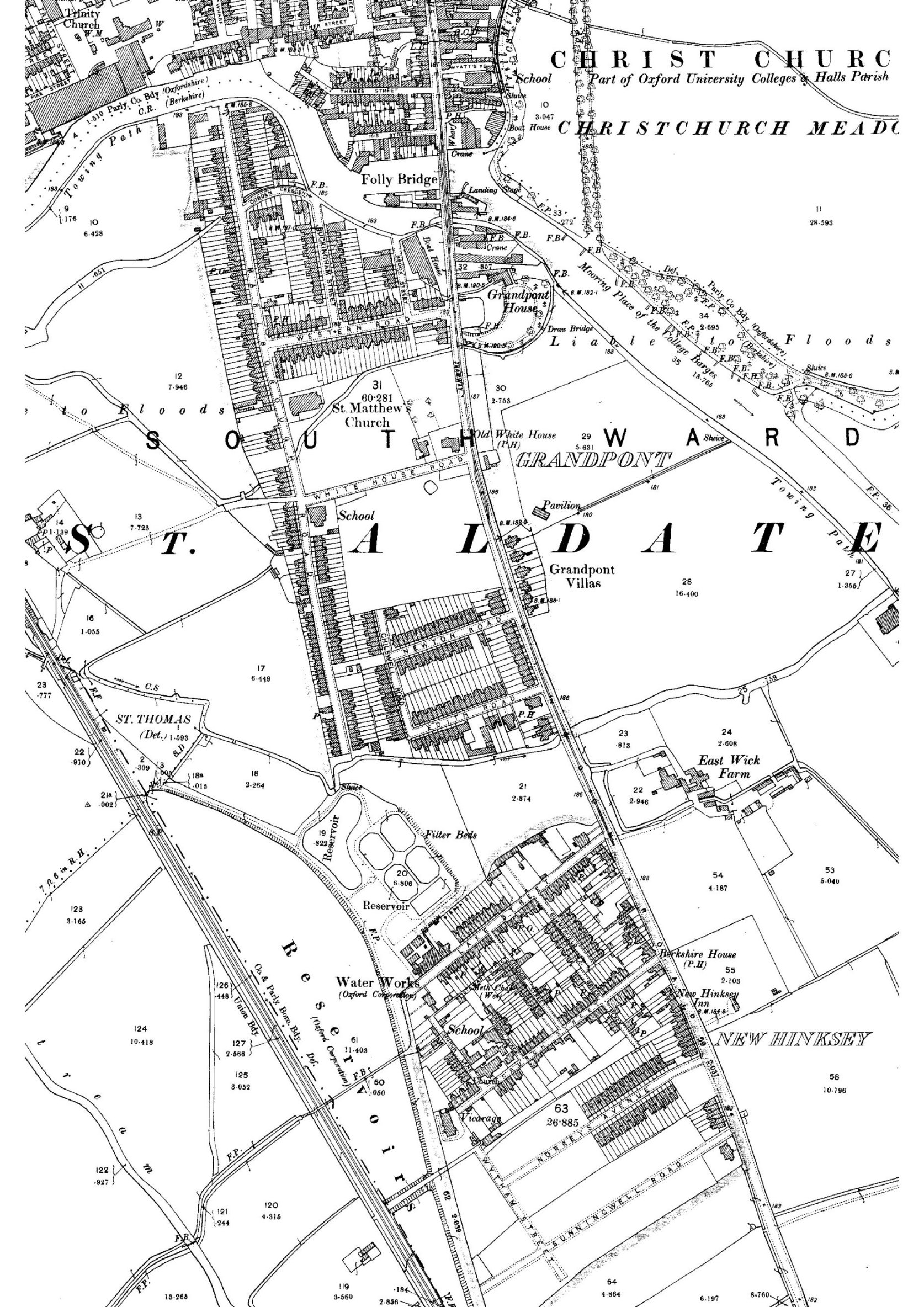
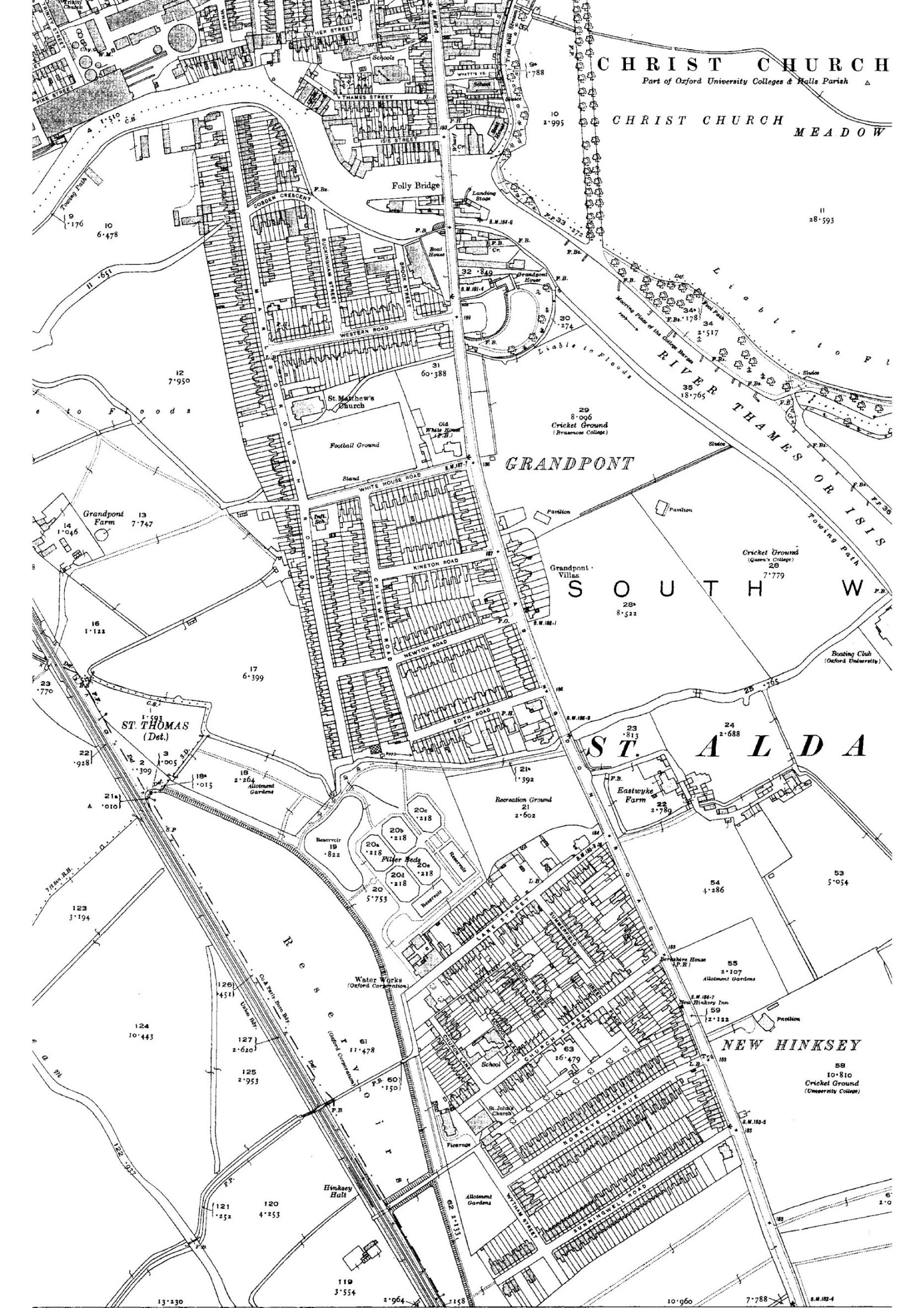
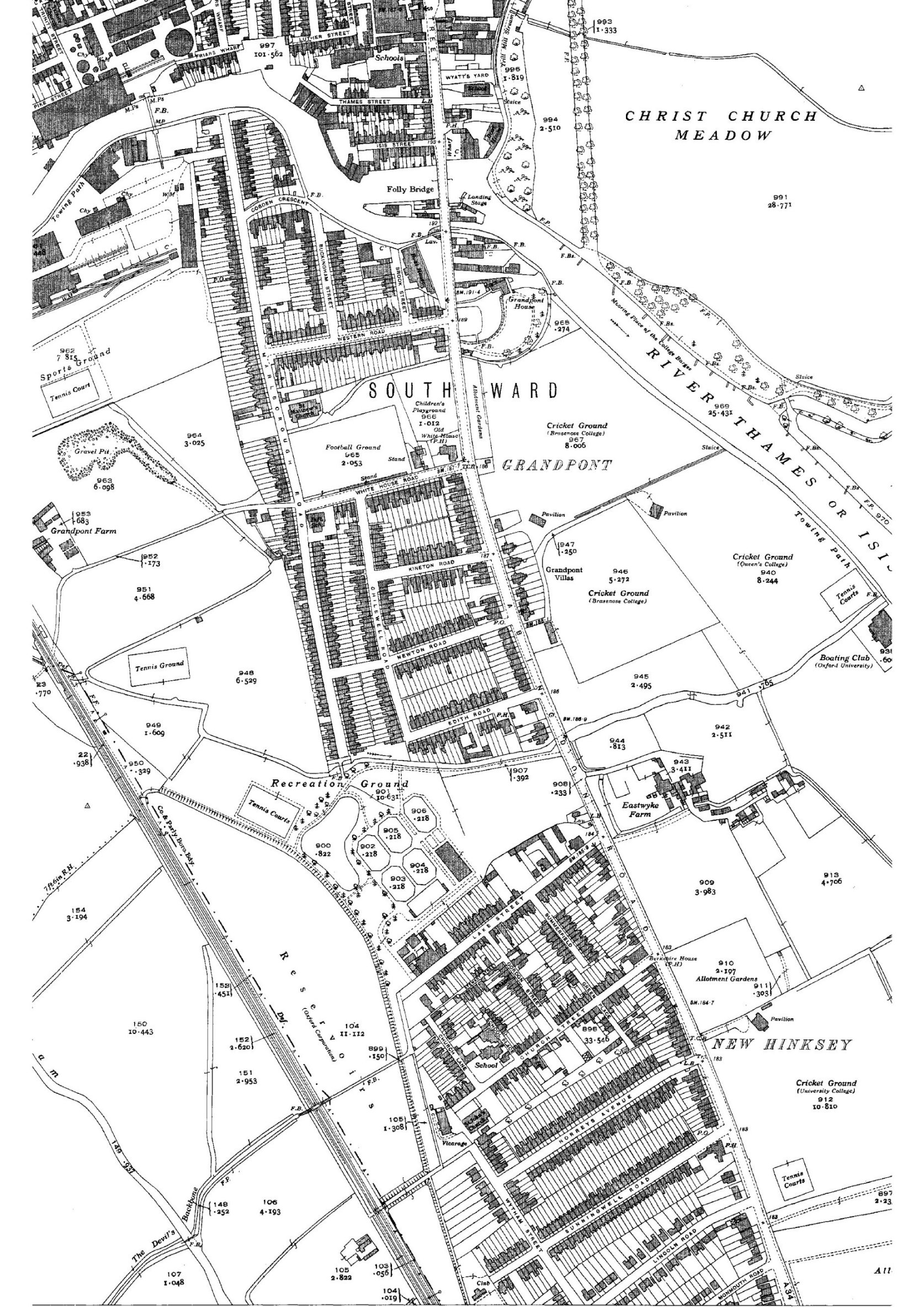
Here are extracts from Ordnance Survey maps of 1878, 1900, 1921 and 1939 (original scale 1:2,500) showing the development of Grandpont and New Hinksey:
Housing development south of New Hinksey
In 1891 William Farthing, a London architect and surveyor, laid out a housing estate immediately south of New Hinksey. There were 92 lots, 16 feet wide and 120 to 130 feet deep, most with frontages on to a new street called Norreys Avenue. The following year, land to the south of Norreys Avenue was laid out for Charles Gillman, an Oxford photographer and printseller (of Gillman & Soame) by the Oxford surveyors Galpin & Son. Most of the 114 lots were on a new street called Sunningwell Road. Both estates were intended for a superior class of artisans' dwellings. Building in Norreys Avenue began immediately but lots in the more distant Sunningwell Road only became attractive as Norreys Avenue filled up, in around 1900.
- Most of the information on this page comes from Malcolm Graham, The Suburbs of Victorian Oxford: Growth in a Pre-Industrial City (DPhil dissertation, University of Leicester, 1985).
- Read about continuing 20th-century development in South Oxford.
- Find out the meaning of street names in Grandpont and South Oxford.
- To find out more about Grandpont and South Oxford in the late 19th century, and particularly for old photographs of people and buildings see Carole Newbigging, The Changing Faces of South Oxford and South Hinksey, Books 1, 2 and 3 (Robert Boyd Publications, 1998-2003).
The Radburn family outside 50 Chilswell Road in c. 1905. Image from Carole Newbigging, The Changing Faces of South Oxford and South Hinksey, Book 3 (Robert Boyd Publications, 2003). (Click image to close)
![[50 Chilswell Road, Radburn family, c.1905]](/images/photos/Local_history_section/Suburban_development/50 Chilswell Road Changing Faces.jpg "50 Chilswell Road, Radburn family, c.1905")
Looking west along Edith Road, probably in the early 20th century. Image © The Oxfordshire County Council, the Oxfordshire History Centre, ref D273566a (Click image to close)
![[Edith Road, D273566a]](/images/photos/Local_history_section/Suburban_development/Edith Road D273566a.jpg "Edith Road, D273566a")
Looking along Lake Street towards the Abingdon Road during flooding in 1890. (Click on image to close)
![[Lake St flooded, 1890, Taunt]](/images/photos/Local_history_section/Pubs/Lake_St_flooded_1890_Taunt.jpg "Lake St flooded, 1890, Taunt")
Plan of Grandpont Villas, built c. 1859 on the eastern side of Abingdon Road, from the 'Vellum Book' Schedule of the property of the city of Oxford, © The Oxfordshire History Centre. (Click image to close)
![[Grandpont Villas plan, Vellum Book]](/images/photos/Local_history_section/Suburban_development/City properties Vellum Book p.x plan 221 Grandpont Villas.jpg "Grandpont Villas plan, Vellum Book")
Map accompanying Daniel Trinder's Award 1844, showing the proposed line of the Great Western Railway as it approached Oxford, just to the west of the Abingdon Road [east is at the top]. The line terminated with a station just to the south-west of Folly Bridge. Henry Greenaway's two fields between the Abingdon Road and the railway line were to become the site of New Hinksey. Image © The Oxfordshire History Centre. (Click image to close)
![[Map accompanying Daniel Trinders Award 1844]](/images/photos/Local_history_section/Railway/Map accompanying Daniel Trinders Award 1844 line of proposed GWR railway.jpg "Map accompanying Daniel Trinders Award 1844")
Extract from the map accompanying Daniel Trinder's Award 1844 (which shows the proposed line of the Great Western Railway as it approached Oxford, just to the west of the Abingdon Road [east is at the top]). Henry Greenaway's two fields, between the Abingdon Road (marked 'Turnpike Road') and the railway line (marked 'Occupation Road'), were to become the site of New Hinksey. Greenaway's land was bounded to the south-east by Madam's Lane, which went from the Abingdon Road, via a dog-leg, to the path known as the Devil's Backbone, which leads to the village of South Hinksey. Madam's Lane became subsumed by future housing development, though it remained an open area between the gardens of the houses on the southern side of Vicarage Road and the northern side of Norreys Avenue, until an extension to Green Place was built over part of it in the 1970s. Image courtesy of Brasenose College, ref: D0530. (Click image to close)
![[Map accompanying Daniel Trinders Award 1844, Henry Greenaway fields]](/images/photos/Local_history_section/Suburban_development/Map_colour_accompanying_Daniel_Trinders_Award_GWR_railway_route_1844_BNC_archives_D0530_Henry_Greenaway_fields.JPG "Map accompanying Daniel Trinders Award 1844, Henry Greenaway fields")
Cartoon of 'The Grandpont Express' from a postcard entitled 'A Bit of Old Oxford', from Stephanie Jenkins's Oxford History website. (Click image to close)
![[Grandpont Express]](/images/photos/Local_history_section/Abingdon_Road/The_Grandpont_Express_tram.gif "Grandpont Express")